

-
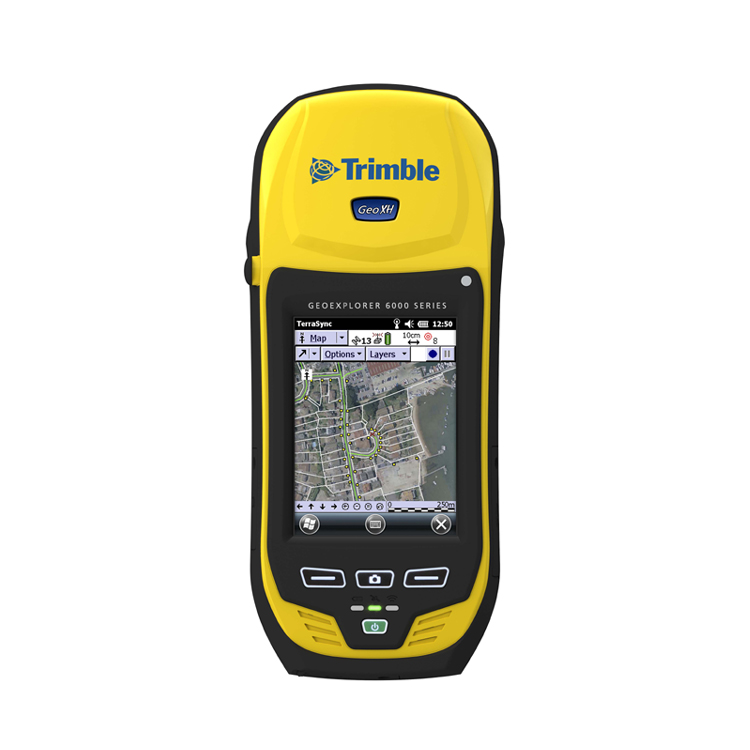
Product DescriptionCompany Info.<>
- Model:
- GeoExplorer6000XH
- Place of origin:
- import
- Memory:
- 4G
- GPS positioning accuracy:
- centimeter-level
main feature
Trimble Floodlight Satellite Shadow Elimination Technology
More positioning in difficult environments for higher accuracy
Sunlight visible display
Still visible in bright sunlight
3.5G cellular communication function
Field high-speed Internet access
5 megapixel autofocus camera
Take high quality photos and link directly to properties
Field replaceable battery
It can support a whole day's work and has the convenience of replacing batteries directly without shutting down.
Trimble GeoExplorer 6000XT/XH (sub-meter/decimeter/centimeter class)
product model GeoXT GeoXH precision Yami decimetre/centimetre Floodlight choosable are cellular modem choosable choosable camera 5 million pixels 5 million pixels battery life GeoXT GeoXH GNSS 11 hours 9 hours GNSS and Wi-Fi 9.5 hours 8 hours GNSS and cellular modems 7 hours 6.5 hours Standby time (typical) 50 days 50 days Technical specifications:
GNSS
- Trimble Maxwell 6 GNSS
- Chip set channels: 220 channels
- System: GPS, GLONASS, WAAS/EGNOS/MSAS/GAGAN
- * Positioning time: 45 seconds (typical)
- NMEA-0183 Support: Optional
- RTCM support: RTCM 2.x/RTCM 3.x
- CMR Support: CMR/CMR+/CMRx
GeoXT Handset:
- GPS: L1C/A
- GLONASS:L1C/A, L1P
GeoXH Handset:
- GPS:L1C/A, L2C, L2E
- GLONASS:L1C/A, L1P, L2C/A, L2P
GNSS accuracy:
GeoXH (cm) version:
---Real-time cm output:
- Horizontal (external antenna): 1 cm + 1 ppm
- Vertical (external antenna): 1.5 cm + 2 ppm
- Horizontal (built-in antenna): 2.5 cm + 1.2 ppm
- Vertical (built-in antenna): 4 cm + 1.5 ppm
----Post-processing cm output:
- Horizontal (external antenna): 1 cm + 1 ppm
- Vertical (external antenna): 1.5 cm + 1 ppm
- Horizontal (built-in antenna): 2.5 cm + 1.2 ppm
- Vertical (built-in antenna): 4 cm + 1.5 ppm
All GeoXH configurations
--Real-time and post-processing H-Star (Horizontal RMS)
- H-Star:10 cm + 1ppm
All GeoXH and GeoXT configurations
--Real-time DGNSS (Horizontal RMS)
- Code: 75 cm + 1ppm
- SBAS: (WAAS/EGNOS/MSAS) Typical 1 m
--Post-processing DGNSS (Horizontal RMS)
- Code 50 cm + 1 ppm
- Carrier (after 45 minutes) 1 cm + 2 ppm
temperature
- Operating temperature: 20 C to +60 C (4 F to +140 F)
- Storage temperature: 30 C to +70 C (22 F to +158 F)
Environmental (MIL-STD-810G)
- Drop, impact 1.2 m (4 ft) drop on plywood laid on concrete
- Functional Impact Test Method 516.6 Procedure I
- Vibration Method 514.6 Procedure I
- Relative humidity 95% No condensation
- * High operating altitude 3,658 m (12,000 ft)
- * Large storage altitude 5,000 m (16,400 ft)
level of protection
- Waterproof/dustproof IP65
size and weight
- Length 234 mm: (9.2 inches)
- Width 99 mm: (3.9 inches)
- Thickness 56 mm: (2.2 inches)
- Weight (including batteries): 925 g (2.0 lb)
cell
- Type: Replaceable, rechargeable lithium battery
- Capacity: 11.1V 2.5 AH
- Charging time: 4 hours (typical)
Connectors and inputs
- Built-in microphone and microphone
- Mini USB interface
- DE-9 serial port and optional USB-to-serial adapter
- External power socket
- SIM slot
- SDHC card slot
camera
- Still mode AF 500 megapixels
- Still Life Photo Format JPG
- Video Mode Resolution * Up to VGA
- Video file format WMV with audio
Cellular mobile and wireless
- UMTS/HSDPA 850/900/2100 MHz
- GPRS/EDGE 850/900/1800/1900 MHz
- Wi-Fi 802.11 b/g
- Bluetooth v2.1 + EDR
viewing screen
- Type: Transflective LED-Backlit LCD
- size: 4.2 (analog)
- Resolution: 480 x 640
- Brightness: 280 cd/m2
hardware
- Processor TI OMAP 3503
- RAM 256 MB
- Flash memory 2GB
- External storage SD/SDHC * up to 32 GB
language
- English, Spanish, French, German, Italian, Portugal (Brazil), Chinese (Simplified), Korean, Japanese and Russian
packing detail
- GeoExplorer 6000 Series Handsets
- sack
- hand strap
- USB cable
- rechargeable battery pack
- AC power adapter
- Screensaver tool
- Spare stylus and stylus lanyard
- relevant document
optional accessories
- Trimble Zephyr Model 2 External GNSS Antenna
- Trimble Tornado external GNSS antenna (GeoXH handset)
- Trimble Tempest external GNSS antenna (GeoXT handset)
- vehicle power supply
- 1.5 m and 5 m external antenna cables
- centering rod for external antenna
- Carbon fiber centering rod set
- External antenna backpack
- Vehicle mounting bracket
- Rigid Shipper Zero Modem Cable
- USB to serial adapter cable
software external compatibility
- Trimble TerraSync software
- Trimble GPScorrect extension for Esri ArcPad software
- Trimble GPS Controller Software
- Trimble GNSS Connector software
- Trimble GPS Pathfinder Office software
- Esri for Desktop software
- Trimble GPS Analyst Extension Module
- Trimble TrimPix Pro System
- Customer applications developed through GIS Developer Community software development kits (SDKs)
- Based on NMEA third-party applications
- Name(chinese)
- Name(English)
- Nanjing Juncan Instrument Equipment Co., Ltd.
- China credit code
- Identity Verification
- Product Category
- RTK measurement systemHandheld GPS/GIS data collector
- Address
-
Gulou District, Nanjing, Jiangsu, China
- Nearby port
- Nanjing
Nanjing Juncan Instrument and Equipment Co., Ltd.(www.njjc17.com) is a high-tech comprehensive enterprise integrating instrument sales, maintenance services, instrument verification, technical consulting, and GIS development. Since its establishment, the company has been committed to providing complete instruments, equipment and technical support for construction, geology, minerals, surveying, ocean, agriculture, forestry, land, electricity, water conservancy and education systems. We focus on the specialization, advancement and high-quality of surveying and mapping instruments, test instruments, and communication equipment. The company's main products: surveying and mapping instruments, non-destructive testing instruments, hydrological measuring instruments, hardware tools, walkie-talkies, telescopes, etc., surveying and mapping instruments calibration and proxy verification. Surveying and mapping instruments: RTK measurement system, total station, theodolite, level, laser rangefinder, ranging telescope, line marking instrument, handheld GPS locator, high-precision GIS data collector, compass, planimeter, cable altimeter, laser pointer, etc.; Non-destructive testing instruments: steel bar position tester, floor thickness gauge, digital rebound meter, crack width tester, crack depth finder, steel bar corrosion meter, etc.; Hydrological measuring instruments: current meters, depth gauges, flow meters, etc.; Hardware tools: digital angle ruler, electronic level ruler, etc.; Interphone: explosion-proof intercom, building intercom, etc.; Telescopes: binoculars, military telescopes, etc. Working hours: Monday to Saturday 8:45-11:45AM 13:30-17:30PM New and old customers are welcome to purchase at bargain prices! You can test the machine at your door! Company address: Room 528, Jinqiao Lighting City (Jinhai Market), No. 98 Jianning Road, Xiaguan District, Nanjing City. Nanjing Juncan will serve you wholeheartedly! Our purpose: starts with customer needs and ends with customer satisfaction!- Name(chinese)
- Name(English)
- Nanjing Juncan Instrument Equipment Co., Ltd.
- China credit code
- Identity Verification
- Product Category
- RTK measurement systemHandheld GPS/GIS data collector
- Address
-
Gulou District, Nanjing, Jiangsu, China
- Nearby port
- Nanjing
Nanjing Juncan Instrument and Equipment Co., Ltd.(www.njjc17.com) is a high-tech comprehensive enterprise integrating instrument sales, maintenance services, instrument verification, technical consulting, and GIS development. Since its establishment, the company has been committed to providing complete instruments, equipment and technical support for construction, geology, minerals, surveying, ocean, agriculture, forestry, land, electricity, water conservancy and education systems. We focus on the specialization, advancement and high-quality of surveying and mapping instruments, test instruments, and communication equipment. The company's main products: surveying and mapping instruments, non-destructive testing instruments, hydrological measuring instruments, hardware tools, walkie-talkies, telescopes, etc., surveying and mapping instruments calibration and proxy verification. Surveying and mapping instruments: RTK measurement system, total station, theodolite, level, laser rangefinder, ranging telescope, line marking instrument, handheld GPS locator, high-precision GIS data collector, compass, planimeter, cable altimeter, laser pointer, etc.; Non-destructive testing instruments: steel bar position tester, floor thickness gauge, digital rebound meter, crack width tester, crack depth finder, steel bar corrosion meter, etc.; Hydrological measuring instruments: current meters, depth gauges, flow meters, etc.; Hardware tools: digital angle ruler, electronic level ruler, etc.; Interphone: explosion-proof intercom, building intercom, etc.; Telescopes: binoculars, military telescopes, etc. Working hours: Monday to Saturday 8:45-11:45AM 13:30-17:30PM New and old customers are welcome to purchase at bargain prices! You can test the machine at your door! Company address: Room 528, Jinqiao Lighting City (Jinhai Market), No. 98 Jianning Road, Xiaguan District, Nanjing City. Nanjing Juncan will serve you wholeheartedly! Our purpose: starts with customer needs and ends with customer satisfaction! -
Send your message to this supplier*From:*To:
 Mr. Tang
*Message:
Mr. Tang
*Message:Inquiry
Copyright © 2003 - 2026 Goepe.com All rights reserved.